หาดหยงหลิง
หาดหยงหลิง ตั้งอยู่ในบริเวณหน่วยพิทักษ์ 2 ของอุทยานแห่งชาติเจ้าไหม อำเภอกันตัง จังหวัดตรัง เป็นหาดทรายรูปโค้งขนานไปกับดงสนทะเลขนาดใหญ่ ที่ขึ้นอยู่อย่างหนาแน่นตั้งแต่ปากทางเข้าไปจนสุดแนวชายหาด ทำให้บรรยากาศดูร่มเย็นเหมาะแก่การนั่งพักผ่อนชมทิวทัศน์เป็นอย่างยิ่ง
คำว่า “หยงหลิง” มาจากภาษามลายูท้องถิ่นปักษ์ใต้ โดย “หยง” แปลว่า แหลม และ “หลิง” แปลว่า กะลาสีเรือ เนื่องจากในโบราณมีการเล่าสืบต่อกันมาว่า เคยมีเรือสำเภามาล่มแถวนี้ เนื่องจากในอดีตเป็นเส้นทางขึ้นล่องของเรือสำเภาจากเมืองปีนัง เพื่อเข้ามาค้าขายในจังหวัดต่างๆ ทางฝั่งอันดามัน
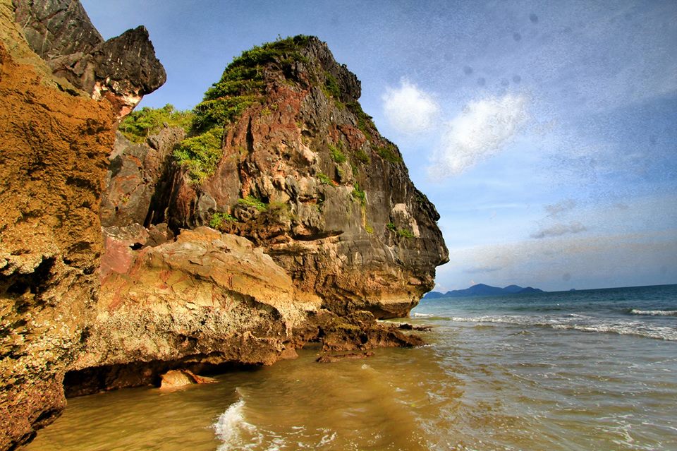
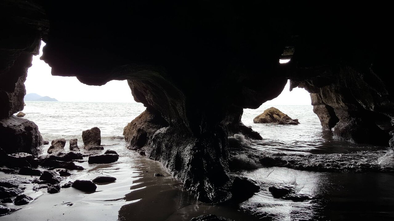
ทางด้านเหนือของชายหาดแห่งนี้ จะเป็นที่ตั้งของ “เขาหยงหลิง” เขาหินปูนที่มีรูปทรงแปลกตา หรือมีลักษณะเหมือนกับจมูกของมนุษย์ แถมยังมีหน้าผาที่สูงชันอย่างมากด้วย สลับกับตันไม้น้อยใหญ่ที่ขึ้นแทรกอยู่ตามโขดหินในขนาดต่างๆ ถือเป็นความงดงามที่ธรรมชาติสรรค์สร้างเอาไว้ นอกจากนั้น ยังมีวุ้งเวิ้ง และโพรงถ้ำตรงบริเวณสุดชายหาด ซึ่งเมื่อน้ำลดก็จะสามารถเดินลอดช่องหินไปโผล่อีกด้านหนึ่ง และมีโขดหินตะปุ่มตะป่ำเหมือนป้อมโอบล้อมลานทราย ที่มีลักษณะเป็นโค้งเว้ารูปพระจันทร์เสี้ยว ก่อให้เกิดมุมมองดีๆ สำหรับการถ่ายภาพที่ออกมาอย่างสวยงาม
การที่ชายหาดแห่งนี้มีน้ำทะเลใสสะอาด และมีทรายละเอียด จึงเป็นที่ชื่นชอบของนักท่องเที่ยวที่ต้องการทำกิจกรรมต่างๆ ด้วยความสนุกสนาน โดยเฉพาะการเล่นน้ำ การพายเรือคายัค และการเดินป่าเพื่อไปยัง “ถ้ำหยงหลิง” รวมทั้งยังสามารถมากางเต็นท์ค้างแรมได้อย่างปลอดภัย
ดังนั้น จึงเป็นแรงบันดาลให้ “ศักดิ์สิริ มีสมสืบ” นักเขียนกวีซีไรต์ ประจำปี 2535 ได้แต่งเพลง พร้อมทำนอง และขับร้อง เพื่อบรรยายถึงความงดงามของ “หาดหยงหลิง” เปรียบดังเจ้าหญิงแห่งเมืองตรัง ซึ่งเพียงแค่ขึ้นต้นบรรเลงตัวโน้ตด้วยเปียโน และเสียงนุ่มๆ ก็สามารถสร้างอารมณ์รักได้อย่างสุดแสนประทับใจ
“เพลงทะเลคลื่นลม ระงมระคน สนทะเลสยายใบ ภูเขากั้นเวิ้งทราย ฉายแวววับวาว เว้าเป็นอ่าวโค้งไกล เกาะน้อยลอยใกล้ไกล เมฆน้อยลอยล่องไป รื่นรมย์ยามเราเอนกาย บนผืนทรายหาดหยงหลิง ถ้าเธอได้รู้จัก แล้วเธอจะรักหยงหลิง ถ้าใครได้รู้จัก แล้วเธอจะรักหยงหลิง เจ้าหญิงแห่งเมืองตรัง”
สำหรับการเดินทางไปยัง “หาดหยงหลิง” นั้น จะใช้เส้นทางหลวงหมายเลข 4046-4162 เมื่อถึงหาดปากเมง ให้เลี้ยวซ้ายวิ่งไปตามถนนเลียบชายหาดประมาณ 10 กิโลเมตร และให้เลี้ยวขวาเข้าถนนสายหาดเจ้าไหม-บ้านน้ำราบ เดินทางต่อประมาณ 6 กิโลเมตร ก็จะมีทางแยกขวาเข้าสู่ชายหาด อีกประมาณ 2 กิโลเมตร
Yong Ling Beach
Yong Ling Beach is located in Kantang district, Trang province, under the care of Hat Chao Mai National Park Protection Unit 2. It is a curved beach with a peaceful atmosphere from a large grove of sea oak that grows along from the entrance to the end of the beach, which makes this place much suitable for sitting back and relax.
The word “Yong Ling” comes from the Malay language which is a local language of southern Thailand. “Yong” means sharp or pointed, and “Ling” means sailors. From the past, the story has been told that there was a junk boat capsized around this area, since the area used to be a route for the junk boat from Penang city to come and trade with various provinces on the Andaman coast.
There is a limestone mountain with a peculiar shape that looks like a human nose, called “Yong Ling Mount” at the north side of the beach. The mountain has a steep cliff and various sizes of trees growing around the rocks, such a beautiful thing that nature has created.
Moreover, there is a cave at the end of the beach that can walk through to the other side when the tide recedes, and also ragged rocks that look like a fortress encircling the crescent-shaped sandy beach. Because of all these features, you can take a lot of beautiful pictures from many perspectives.
Yong Ling Beach has clear blue water and fine white sand, which makes it popular for tourists who would like to enjoy water activities, especially swimming, Kayaking, trekking to “Yong Ling Cave”, and camping safely at the beach.
Therefore, this beach is an inspiration for “Saksiri Meesomsueb”, a poet who won the S.E.A. Write Award in 1992, to compose a song with melody and also sing it to describe the beauty of “Yong Ling Beach” that can even be called “a princess of Trang”. The song can impressively convey the emotion of love by the piano notes and a soft, beautiful voice.
“The song of the sea, waves, and wind, loudly mingle together. The sea oak spread its leaves. The mountain dividing curvy sea cove, sparkly shining. Little islands floating near and far, little clouds wander along the sky. Feeling delightful when we lay down on the sand of Yong Ling Beach. You will love Yong Ling if you know her. Everyone will do if they had known Yong Ling, the princess of Trang.”
For traveling to “Yong Ling Beach”, take Highway no.4046-4162. When reaching Pak Meng Beach, turn left and go along the road about 10 kilometers, then turn right into Hat Chao Mai-Ban Nam Rab road. Continue for about 6 kilometers, there will be a junction on the right leading to the beach for about 2 kilometers.
勇铃海滩
勇铃海滩位于董里府干东县的照买国家公园的二号保护区,为了营造一个有着凉风习习吹过而且可以坐着休息观看风景的好环境,勇岭海滩从入口到海滩的延长线有着茂密的森林。
“勇铃”一词来源于马来南部方言,“勇/yong”译为半岛;“铃/ling”译为水手,古时候有传言说,曾经有小船在这附近沉没,也有说法是(勇铃海)过去是一条从比南城去安达曼岸边与各府做贸易的航道。
海滩的北面,有座勇铃山,山有着很新奇的样子比如有着像人类鼻子一样的特征,另外还有着非常多的悬崖峭壁,与大大小小的树木夹杂在各种形态的石岗,造就了大自然的鬼斧神工的美丽。除此之外,还有着大片的空地和洞穴,洞穴里水滴石穿,坑坑洼洼的石头像是围绕着沙场的堡垒,像极了弯弯的月亮,给想拍一些漂亮的照片的人来说创造了非常好的想法。
这片海滩有着清澈干净的海水,细腻的沙滩,游客可以开心地在此开展各种活动,比如玩水,划船或者去森林里走走,看看勇岭洞,顺便还可以安心的在外面露营。
在1992年就有一位作家产生了强烈的“灵感”做出了一首歌曲,讲述“勇岭海滩”的美,歌曲里讲述了将勇岭海滩比作董里府的少女,伴随着钢琴的伴奏,轻轻的唱出了对勇岭海滩深深的爱。
闷热中掺杂海浪声,阵阵海浪,山拦着沙,一隐一现闪闪发光,海湾逐渐远去,小岛也越漂越远,小小的云也欢欢喜喜的卧在了勇岭海滩上,如果你知道勇岭,那么你会爱上她,无论谁知道,谁都会爱上她,爱上勇岭,这座董里府的“少女”。”
关于“勇岭海滩”的行程路线,可以上4046-4162号高速公路,如果到了巴明海滩,左转沿着海岸线走10公里然后右转到了照买路-班南姆拉继续走6公里,然后从右边路口再走两公里就到达海滩了。